


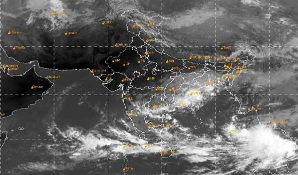
Chennai : Two days after the depression, which wrecked havoc in Chennai city, suburbs, coastal and delta districts of Tamil Nadu, crossed the coast, a fresh low pressure area has formed over South Andaman sea and adjoining Thailand coast on Saturday.
The new system is expected to bring more rains in some parts of the State. The officials in the meteorological department were closely monitoring the movement of the system.
Met office in a bulletin said the cyclonic circulation over Gulf of Thailand and neighbourhood concentrated into a low pressure area over south Andaman sea and adjoining Thailand coast.
It is likely to move west-northwestwards and concentrate into a depression over North Andaman sea and adjoining south east bay of bengal on Monday.
“Then it is likely to continue to move west-northwestwards, intensify further and reach near Andhra Pradesh coast around November 18”, the bulletin said.
Meanwhile, the depression, which crossed the coast near Chennai on November 11 evening, became less marked today, Though there were no rains since Thrusday evening, the woes of the people continued as several areas and households continued to remain waterlogged.
People in Perambur, West Mambalam, Ashok Nagar and those in western and northern suburbs, were the worst affected as stagnation continued for the fourth successive day, affecting normal life.
While the Greater Chennai Corporation authorities were working overtime to pump out the rain water in stagnated places, a few roads and three subways in the city still remained shut in view of water logging.
People of Ashok Nagar staged a protest demanding restoration of power supply, which was disconnected due to inundation, and urged the authorities to speed up the works to clear the stagnated rain water.
Meanwhile, met office has forecast thunderstorm with light to moderate rain in some areas of Chennai city for the next 24 hours.
Exclusive
Breaking News


More Stories
Puri BRICS Disaster Risk Reduction Meeting Opens; Odisha CM Calls for Stronger Global Cooperation
India–U.S. Agricultural Cooperation Gains New Momentum Through Key Dialogue Led by IFFCO Chairman Dileep Sanghani
Bear enters Primary Health Center premises, Video goes on viral