
Bhubaneswar : Odisha government today alerted the collector of districts under yellow warning issued by the Met department to remain prepared in view of heavy rains likely to be triggered by a low pressure area(LOPAR) .
Met sources said a low pressure area over coastal areas of north Andhra Pradesh and south Odisha and adjoining west central bay of bengal would cause rains for next three days in many parts of Odisha .
The collectors were asked to meet situations arising out of any water logging,landslides,localised flood like situation including urban areas due to rains .
They were advised to keep continuous vigil of low lying areas and dewatering wherever required including urban areas.
As per the midday weather bulletin issued by IMD on Saturday the southwest monsoon withdrawal line continues to pass through Kohima, Silchar, Krishnanagar, Baripada, Malkangiri, Nalgonda, Bagalkot and Vengurla
Under its impact, thunderstorms with lightning and heavy rainfall are likely to occur at one or two places of several districts in Odisha in the next three days.
The squally weather with occasionally surface wind speed reaching 40-50 kmph very likely over west central and adjoining northwest bay of bengal off odisha coasts during next 24 hours.
The squally weather with surface wind speed reaching 40-50 kmph gusting to 60 kmph very likely over the deep sea areas of north bay of Bengal during October 17 to October 19 next.
The fishermen are advised not to venture into the deep sea areas of west central & adjoining northwest bay of Bengal off odisha coasts during next 24 hours and deep sea areas of north bay of Bengal till October 19.
The district collectors of yellow warning have been asked to ensure functioning of the control room round the clock and report the rainfall besides the situation report to the control room of the Special Relief Commission (SRC) office.
Exclusive
Breaking News
 Trailer JCC General body meeting held at Paradip
 CIPET PPEC Paradip planted 400 saplings during plantation drive week
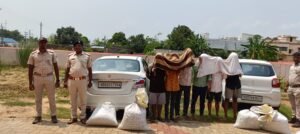
 Excise department seizes 52 Kg Ganja in Major Anti-Drug Crackdown
 Human Chain to mark World Day against Child labour
 Local appreaciated Patna MLA’s representative efforts, Helpless woman get help


More Stories
Trailer JCC General body meeting held at Paradip
CIPET PPEC Paradip planted 400 saplings during plantation drive week
Human Chain to mark World Day against Child labour