


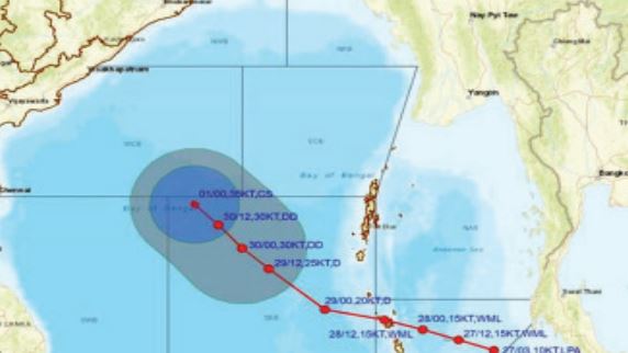
Bhubaneswar: A cyclonic storm is likely to form over the southwest Bay of Bengal around December 1, the India Meteorological Department (IMD) informed on Monday. “Under the influence of yesterday’s cyclonic circulation over South Andaman Sea and adjoining south Thailand, a low pressure area formed over south Andaman Sea & adjoining Malacca Strait at 8.30 am today. It is likely to move westnorthwestwards and intensify into a depression over southeast Bay of Bengal around November 29. Thereafter, it is likely to move northwestwards and intensify further into a cyclonic storm over southeast Bay of Bengal during subsequent 48 hours,” it said. Though the weather agency is yet to make any prediction on its likely movement towards the coast and landfall, the IMD GFS indicates that the system may cross Andhra Pradesh-South Odisha coasts on December 5 as a very severe cyclonic storm. According to Tropical Weather Outlook issued by the IMD, most of the models are indicating formation of depression over South Bay of Bengal during November 29-30, it’s intensification into a cyclonic storm and it’s northeastwards recurvature. However, there is variation among various models on the area of formation of depression, time of formation and point of recurvature. IMD GFS is indicating extended low-pressure area over southwest Bay of Bengal on November 2, depression on November 3 and cyclonic storm on December 1 over the same region. It is indicating further intensification of the system and its northnorthwestwards movement till December 4 and then northnortheastwards recurvature. The system is indicated to cross North Andhra Pradesh-South Odisha coasts on December 5 as a very severe cyclonic storm. Thereafter, it is indicated to move along coast with rapid weakening. ECMWF is indicating formation of Depression on November 29 over southeast Bay of Bengal. It is also indicating intensification into cyclonic storm on December 2 over the same region. Further intensification is also suggested. It is also indicating crossing over North Andhra Pradesh-South Odisha coasts, but on December 6. NCUM is indicating formation of low pressure area over southeast Bay of Bengal on November 30 with westnorthwestwards movement till December 3. As a low-pressure area and depression over southwest Bay of Bengal on December 4 (delayed development as compared to other models). It is also suggesting further intensification into a severe cyclonic storm. IMD Multi Model Ensemble (MME) is indicating formation of depression around November 29 with initial west-northwestwards movement till November 30. Thereafter, the system is indicated to recurve gradually north-northeastwards. Peak intensification up to severe cyclonic storm stage is indicated. Senior meteorologist Jason Nicholls had earlier tweeted: “A tropical low is crossing the Malay Peninsula toward the Andaman Sea & can become a depression in the Bay of Bengal around midweek. Good chance to become Cyclonic Storm Michaung before threatening eastern India or Bangladesh next weekend or early the following week.” If the system intensify into a cyclone, it will be called Michaung, a name suggested by Myanmar. It will be the sixth such event forming in the Indian Ocean this year, compared to the customary four cyclones that occur in most years, and the fourth in the Bay of Bengal. On November 17, a low-intensity cyclone named Midhili had crossed Bangladesh coast with “weak” winds, but caused significant harm, killing at least seven people and destroying scores of homes.
Exclusive
Breaking News


More Stories
Trailer JCC General body meeting held at Paradip
CIPET PPEC Paradip planted 400 saplings during plantation drive week
Human Chain to mark World Day against Child labour