


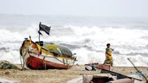
Bhubaneswar: The India Meteorological Department (IMD) informed that the Deep Depression over southwest Bay of Bengal intensified into a Cyclonic Storm Michaung. The system lay centered about 300 km east-southeast of Puducherry, 310 km southeast of Chennai, 440 km southeast of Nellore, 550 km south-southeast of Bapatla and 550 km southsoutheast of Machilipatnam. The cyclonic storm is likely to continue to move northwestwards and further intensify and reach Westcentral Bay Of Bengal off south Andhra Pradesh and adjoining north Tamil Nadu coasts by December 4 forenoon, as per the IMD. “Thereafter, it would move nearly northwards almost parallel and close to south Andhra Pradesh coast and cross South Andhra Pradesh coast between Nellore and Machilipatnam during forenoon of December 5 as a Cyclonic Storm with a maximum sustained wind speed of 80-90 kmph gusting to 100 kmph,” said IMD. Cyclone Michaung is now expected to make landfall between Andhra Pradesh’s Nellore and Machilipatnam on December 5 with a sustained wind speed of 80-90 kmph, gusting to 100 kmph, IMD predicted. IMD has issued a heavy rainfall warning for four districts in Tamil Nadu in relation to Cyclone Michaung. The weatherman have predicted heavy rainfall at isolated places in Chennai, Tiruvallur, Kancheepuram and Chengalpattu districts in the next 24 hours. IMD also predicted moderate rainfall with light thunderstorms and lightning at many places in these districts. Day 1: (Valid up to 0830 Hrs IST of 04.12.23) Light to moderate rain/ thundershower is very likely to occur at a few places over the districts Malkangiri, Koraput, Rayagada, Gajapti, Ganjam and in one or two places over the rest districts of coastal Odisha, Nabarangpur, Kalahandi, Kandhamal, Boudh. Dry weather is very likely to prevail over the rest districts of Odisha. Day 2: (Valid from 0830 Hrs IST of 04.12.2023 to 0830 Hrs IST of 05.12.2023) Light to moderate rain/ thundershower is very likely to occur in many places over the districts of Malkangiri, Koraput, Rayagada, Gajapti, Ganjam, Puri, in a few places over the districts of, Kandhamal, Nawarangpur, Kalahandi, Nayagarh, Khordha, Jagatsinghpur, Cuttack and at one or two places over the rest districts of Odisha. Yellow Warning (Be updated): Heavy rainfall (7 to 11 cm) very likely to occur at one or two places over the districts of Malkangiri, Koraput, Rayagada, Gajapati, and Ganjam. Day 3: (Valid from 0830 Hrs IST of 05.12.2023 to 0830 Hrs IST of 06.12.2023) Light to moderate rain/ thundershower very likely to occur at most places over the districts of South coastal Odisha, Malkangiri, Koraput, Rayagada, Kalahandi, Kandhamal, Nawarangpur and at many places over the rest districts of south interior Odisha, north coastal Odisha and at a few places over the districts of north interior Odisha. Orange warning (Be Prepared): Heavy to very heavy rainfall (7 to 20 cm) very likely to occur at one or two places over the districts of Malkangiri, Koraput, Rayagada, Gajapati, and Ganjam. Yellow Warning (Be updated): Heavy rainfall (7 to 11 cm) very likely to occur at one or two places over the districts of Nabarangpur, Kalahandi, Kandhamal, and Puri. Day 4: (Valid from 0830 Hrs IST of 06.12.2023 to 0830 Hrs IST of 07.12.2023) Light to moderate rain/ thundershower is very likely to occur at most places over the districts of coastal Odisha, and at many places over the districts of Keonjhar, Mayurbhanj, Angul, Dhenkanal, Kandhamal, Rayagada, Malkangiri, Koraput and at a few places over the rest districts of Odisha. Yellow Warning (Be updated): Heavy rainfall (7 to 11 cm) very likely to occur at one or two places over the districts of Ganjam, Gajapati, Puri, Nayagarh, Khurdha, Cuttack, Jagatsinghpur, Kandhamal, Koraput, Malkangiri and Rayagada. Day 5: (Valid from 0830 Hrs IST of 07.12.2023 to 0830 Hrs IST of 08.12.2023), Light to moderate rain/ thundershower is very likely to occur at a few places over the districtsof Odisha.
Exclusive
Breaking News


More Stories
JSW Utkal Steel holds Plantation Drive & Environmental Awareness initiatives
Climate Change a Looming Catastrophe for the Future; World Environment Protection Week Observed in Nimapada
Puri BRICS Disaster Risk Reduction Meeting Opens; Odisha CM Calls for Stronger Global Cooperation