
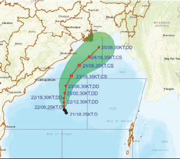
Bhubaneswar: The Depression formed over westcentralBay of Bengal on Sundaymoved west-northwestwards
with a speed of 6 kmph duringthe past 6 hours and lay centeredat about 590 km south of Paradip(Odisha), 740 km south of Digha(West Bengal), and 880 km southsouthwestof Khepupara(Bangladesh). IMD sources heresaid It is likely to further intensifyinto a ‘deep depression’ and likelyto move northwestwards duringthe next 12 hours.The deep depression thenrecurve and move northnortheastwardsduring thesubsequent 3 days towardsBangladesh and adjoining WestBengal coasts. Squally windspeed reaching 40-50 kmphgusting to 60 kmph is likely overNorth Bay of Bengal off OdishaCoast on Monday and it is likelyto increase gradually becomingGale wind speed reaching 60-70kmph gusting to 80 kmph fromOctober 24 to 26 over north Bayof Bengal & squally wind speed50-60 kmph gusting to 70 kmphis very likely along and off Odishacoast.Sea condition will be rough tovery rough over west-central Bayof Bengal till October 25 and itwill be rough on October 23becoming very rough to high fromOctober 24 to 26 over North Bayof Bengal, along & off Odishacoast. Fishermen are advised notto venture into West-central Bayof Bengal till October 26 andalong and off Odisha coast andnorth Bay of Bengal fromOctober 23 to 26. The IMDadvised to hoist DistantCautionary Signal No-I (DC-I) atall ports of Odisha.Uma Shankar Das, IMDScientist in Bhubaneswar said thelow-pressure system hasintensified into a deepdepression and it will furtherintensify into a ‘cyclonic storm’.But it will have not much impacton Odisha and no warning hasbeen issued so far. Das said. Aswind speed is likely to increase,the sea condition is likely toPossible Cyclone…remain rough and hence the fishermen from Odisha havebeen advised to return to the shore by tonight. He said severalparts of coastal Odisha are likely to experience light tomoderate rainfall. Similarly, India Meteorological Department(IMD) informed that the Cyclone ‘Tej’, brewing in the ArabianSea, intensified into an extremely severe cyclonic storm onSunday and is headed towards the Yemen-Oman coasts. Thecyclonic storm is predicted to move northwestwards and crossthe Yemen-Oman coasts between Al Ghaidah (Yemen) andSalalah (Oman), close to the east of Al Ghaidah around noonon October 24 as a very severe cyclonic storm with windspeeds of 115-125 kmph, gusting to 140 kmph, it said. “Thevery severe cyclonic storm ‘Tej’ intensified into an extremelysevere cyclonic storm and lay centred about 160 km eastsoutheastof Socotra (Yemen), 540 km south-southeast ofSalalah (Oman), and 550 km southeast of Al Ghaidah (Yemen)at 8:30 am on Sunday,” the IMD said in a statement.remain rough and hence the fishermen from Odisha havebeen advised to return to the shore by tonight. He said severalparts of coastal Odisha are likely to experience light tomoderate rainfall. Similarly, India Meteorological Department(IMD) informed that the Cyclone ‘Tej’, brewing in the ArabianSea, intensified into an extremely severe cyclonic storm onSunday and is headed towards the Yemen-Oman coasts. Thecyclonic storm is predicted to move northwestwards and crossthe Yemen-Oman coasts between Al Ghaidah (Yemen) andSalalah (Oman), close to the east of Al Ghaidah around noonon October 24 as a very severe cyclonic storm with windspeeds of 115-125 kmph, gusting to 140 kmph, it said. “Thevery severe cyclonic storm ‘Tej’ intensified into an extremelysevere cyclonic storm and lay centred about 160 km eastsoutheastof Socotra (Yemen), 540 km south-southeast ofSalalah (Oman), and 550 km southeast of Al Ghaidah (Yemen)at 8:30 am on Sunday,” the IMD said in a statement.
Exclusive
Breaking News
 Trailer JCC General body meeting held at Paradip
 CIPET PPEC Paradip planted 400 saplings during plantation drive week
 Excise department seizes 52 Kg Ganja in Major Anti-Drug Crackdown
 Human Chain to mark World Day against Child labour
 Local appreaciated Patna MLA’s representative efforts, Helpless woman get help


More Stories
Trailer JCC General body meeting held at Paradip
CIPET PPEC Paradip planted 400 saplings during plantation drive week
Human Chain to mark World Day against Child labour